I'm in the planing stages of a squad-level tactical sci-fi game.
I want the movement and combat system to be somewhat realistic, but I don't what to slow down gameplay too much. (The ever-present problem)
Two areas slowing me down are range and line-of-sight.
Range is easy in theory, this weapon can shoot 4 hexes, that weapon can shoot 10 hexes, etc. The problem is in looking at the board and seeing if you can reach a target. It is not immediatly apparent what your range is without counting individual hexes for different units - very time consuming.
Line-of-sight is a bit harder. (Is this clump of trees in the way, can i see over the lip of that hill, etc.) I already know that this will have to be an apporximation. I have come up with a few simple rules to determine if a unit can be spotted, but as with the range issue, it isn't always immediatly apparent just by glancing at the map.
In both of these cases, you have to analyze each individual situation. Count hexes for range, analyze in-between hexes for LOS.
These things slow the game for even just a few units.
------
So, does anyone have expirence with effective line-of-sight systems?
Perhaps I have been blinding my self to a much simpler way of getting around these problems?
Or does anyone think that these things aren't as bad as I'm making them out to be?


That's pretty close to what I had.
I like the cover idea, giving a bonus to deffence.
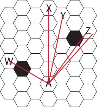
What I had was that a target is blocked if the line of sight (center to center) passes inside of 2 corners of a single blocking hex. (passing inside of just one corner is sighted)
Passing inside just one corner each of multiple blocking hexes is still sighted if they are on the same side of LOS, but blocked if from opposite sides.
That is simplified somewhat by wording it such that if there is no clean LOS from any portion of the attacking and target hex, then target is blocked.
Now, it gets complicated. : )
Hills -This wasn't covered in the older thread.
Dealing with varting terrain levels has some problems. This is further complicated by the issue that a change in elevation over one hex can represent an abrupt change (like a building) or a gradual change (like a slope)
So, if a unit is on top of the edge of a hill he can obviously see into the lower area. But what if he is one hex back from the edge? Now what areas are visible? On top of a building he might see nothing, but on top of the slope, surely something will be visible.
Conversely, a unit can hide behind an obstacle, but at some elevation it becomes targetable again, depending how close to the obstacle it is.
I have some ideas mapped out covering these situations, but I don't have time to post more just now.
I'll try to post with some nice graphics later today.